The 8 best places in Fife to kick flip, nose slide and land!
15 Aug 22
6 MIN READ TIME
08 August 20
Outdoor
Follow Ken Hunter, the Fife Explorer's, adventure rediscovering Fife landscapes during lockdown and climbing The Sleeping Giant (aka Benarty Hill).
Walkabout” is a term said to have originated in Australia, possibly by the wandering Aborigine tribes and maybe being born in Brisbane I have somehow adopted the gene. Not-with-standing I regard myself as a Fifer having been here since the ‘Springtime’ some decades ago.
Fife and a large part of Scotland are my outdoor playgrounds,climbing the Scottish hills and visiting remote corners. That said I had until now climbed only the most prominent Fife hills; Bishop Hill, and East and West Lomond. The Lomond hilltops on a clear calm day provide the ideal spot to suck up the sights and sounds of the nearby rural villages, rolling farmlands, lochs and hills that this compact county offers. The Ochil range formed by the ancient Ochil fault line include the Fife hills as it crosses Fife from Stirlingshire shaping the landscape we see today. There is no better way to appreciate the surrounding landscape than looking down from a high viewpoint. Travelling around Fife for so many years, I am aware of the other lower hills that grace the county but have ignored them in favour of higher viewpoints and the larger mountains of Scotland. Before lockdown I decided to “button” my so-called pride and climb them.
Benarty Hill (The Sleeping Giant as it is known) bordering the shores of Loch Leven succumbed to my trudging in February. The route can be walked at any time and I started in the carpark at Lochore Country Park on the south side. The park has a history; more recently the site of seven local collieries remediated to re-establish the former loch, woods, trails, outdoor activities and wildlife habitats. In medieval times, the ruined Lochore Castle seen on entry to the park governed these lands. A shadow of its former self, it is difficult to imagine this was once a grand stronghold recognised by the armies of William of Orange as one of Scotland’s most impregnable castles. Recent archaeological surveys have verified that the castle is sited on a former island before the surrounding loch was drained by a landowner to produce grazing land for cattle – the island was man-made established by Neolithic hunter-gatherers around 2000-3000BC to site their ancient crannog home.
Moving out from the car park on the tarmacadam path skirting the north side of the loch, the cold morning was peaceful and the calm waters of the loch glistened as Mallard ducks and swans swam quietly by. The cool breeze rippled the water and rustled the trees on an opposite island. Previous days had been stormy and the remnants of persistent heavy rainfall were evident forming large pools at the path edges reflecting the trees and bushes under a blue sky. The route diverts right from the main path through a gated entrance leading up through Harran Wood, rising steeply the gravel beech-lined path was saturated and soft from the previous day’s rainfall. The wood is densely occupied by many native trees, beech, oak and birch and evidence of some coppicing and regeneration is apparent. The morning sun produced a mottled golden light amongst the tree trunks adding to the beauty of the scene as I wandered over the Harran Hill and down to the roadway below. Through a second picket gate the route takes a left turn towards the unclassified Hill Road where crossing directly to the opposite side, a stepped path rises steeply up the forested lower slopes of Benarty Hill. The upper leg muscles are subjected to a keen workout and the lungs heave until the path levels out at a bend where a welcome bench is strategically sited for a well-earned breather.
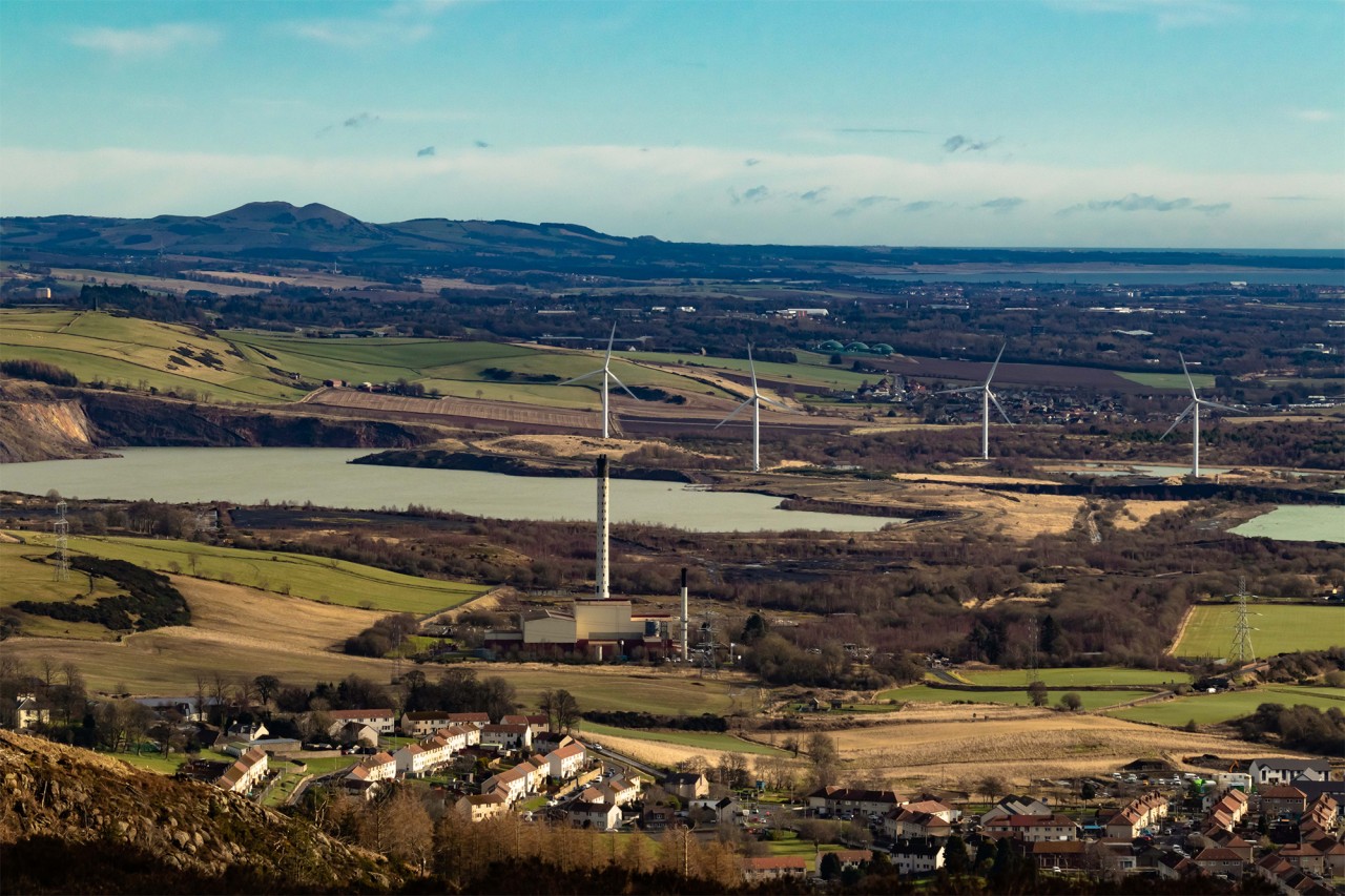
As this wider path leaves the forest a narrow rough path branches north towards the ridge over rugged heather clad ground. Thereafter it is a fairly easy trek onto the summit plateau. The emerging views overlook the Lochore Country Park and neighbouring villages with the rural landscape of Fife stretching out southwards to the River Forth. A broad and lightly snow covered undulating heather moor opened up over the summit plateau. As I reached the edge of the ridge I realised that the Trig Reference pillar was still some distance away on the north side of the plateau. (Had I studied the map earlier I would have known this) – The fence just beyond the trig pillar is well placed as it provides a welcome stop before the ground plunges over the edge near vertically 200m towards the main road that follows the banks of Loch Leven. From my icy vantage point I had a clear view of the higher snow covered Ochil hills in the northwest, then the expanse of wide rural valley to the Bishop Hill, and the Lomond Hills eastwards with Largo Law beyond interrupted by lush green rural farmlands, villages and Loch Leven with St. Serf’s Island in the valley floor, and the RSPB nature reserve on the south side. The blue sky and clear uninterrupted views over the snowy hilltops contrasting with the green valleys below gave a real sense of contentment and connection with the surrounding natural landscape and commanded that I stopped here for a time.
My return to the car park was a pleasant stroll retracing my steps through Harran Wood then altering my route this time round the south side of Loch Ore that by then basked in the afternoon sun. More walkers had appeared enjoying the loch-side path as swans with their young paddled by and a flock of wild geese grazed in the nearby meadow. An area of Fife that offers a true nature experience however you want to pursue it.
Map: OS Landranger Series – No. 58
Lochore Castle History – Information: http://www.stravaiging.com/history/castle/lochore-castle
Lochore Meadows Country Park – Information and How to get there: https://www.lochoremeadows.org.uk/
By Ken Hunter